Ohenhen said the extra pressure from seismic activity can “lead eventually to such high-end catastrophes like a building collapse or more prominent structural failure.”
The good news is that with this knowledge, cities can prepare for a future that involves sinking land.
“As opposed to just saying it’s a problem, we can respond, address, mitigate, adapt,” Ohenhen said in a release. “We have to move to solutions.”
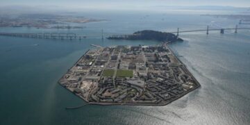
A separate study from this year, also using satellite imagery, found that land along San Francisco Bay in San Rafael, Corte Madera, Foster City and Alameda’s Bay Farm Island is subsiding more than 0.4 inches, about 10 millimeters, a year. When considering the subsidence rate, local sea levels could rise by more than double the regional estimate by 2050.
“Areas might be affected by the rising water much sooner than we anticipate, and that brings by itself increased flooding and tidal inundation,” said Marin Govorcin, the study’s lead author and a NASA remote sensing scientist in Southern California.
According to the study, infrastructure such as San Francisco International Airport could see nearly a foot of sea level rise by 2050.
“What this says is that our situation in relation to flooding is worse than we thought,” said Kristina Hill, a UC Berkeley professor and a leading sea level rise scientist who was not involved in the study. “The region’s economy depends on the airports, so we’ll need to continue to focus on how to adapt those airports to these new conditions.”


